 Climatic Phenomenon
1. What is El Niño
El Niño and La Niña are terms which describe the biggest fluctuation in the Earth's climate system and can have consequences across the globe. The fluctuation sees changes in the sea-surface temperature of the tropical Pacific Ocean which occur every few years.
What causes El Niño?
These events are due to strong and extensive interactions between the ocean and atmosphere. They are associated with widespread changes in the climate system that last several months, and can lead to significant human impacts affecting things such as infrastructure, agriculture, health and energy sectors.
The name 'El Niño' nowadays is widely used to describe the warming of sea surface temperature that occurs every few years, typically concentrated in the central-east equatorial Pacific. 'La Niña' is the term adopted for the opposite side of the fluctuation, which sees episodes of cooler-than-normal sea surface temperature in the equatorial Pacific.
These episodes alternate in an irregular inter-annual cycle called the El Niño Southern Oscillation (ENSO). Southern Oscillation is the term for atmospheric pressure changes between the east and west tropical Pacific that accompany both El Niño and La Niña episodes in the ocean. ENSO is the dominant feature of climate variability on inter-annual timescales.
Research shows that El Niño and La Niña cycle has impacts all over the world.
2. What is La Niña
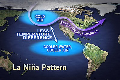
La Niña is a phenomenon that describes cooler than normal ocean surface temperatures in the Eastern and Central Pacific Ocean; regions close to the equator off the west coast of South America. In some parts of the world, La Niña causes increased rainfall while in other regions it causes extreme dry conditions. The conditions that cause La Niña recur every few years and can persist for as long as two years. El Niño occurs every 2-7 years and La Niña events sometimes follow El Niño events. La Niña in the past has also been called as anti-El Niño and El Viejo (the old man in Spanish).
According to National Geographic,
La Niña is a climate pattern that describes the cooling of surface ocean waters along the tropical west coast of South America. La Nina is considered to be the counterpart to El Nino, which is characterized by unusually warm ocean temperatures in the equatorial region of the Pacific Ocean.

What Causes La Niña?
This phenomenon occurs when the easterly trade winds get stronger and blow more warm water west allowing cold water below the sea’s surface to push towards the top near the South American coast to replace the warm water. This, therefore, means that the easterly trade winds are to be blamed for partly causing La Niña. El Niño is the opposite of La Niña. This occurs when the easterly trade winds become weaker and in some cases blows in the opposite direction. The Pacific Ocean during El Niño becomes warm; gains heat and pushes eastward.
During a La Niña period, the sea surface temperatures across the eastern and central Pacific Ocean tend to be lower than the normal temperatures (between 3-5 degrees Celsius). In the United States, for example, La Niña occurs for at least five months of La Niña conditions. This phenomenon has widespread effects on the weather. A usual, La Niña winter features drier and milder conditions across the Southern hemisphere. This causes elevated fire conditions and the Southeast drought conditions. On the other hand, the Pacific Northwest becomes wetter than normal and the Northeast experiences very cold conditions. La Niña sometimes follows El Niño although they occur at asymmetrical intervals of approximately 2-7 years.
What is the Difference between La Niña and El Niño?
As per NOAA, “El Niño and La Niña are extreme phases of a naturally occurring climate cycle referred to as El Niño/Southern Oscillation. Both terms refer to large-scale changes in sea-surface temperature across the eastern tropical Pacific. Usually, sea-surface readings off South America’s west coast range from the 60s to 70s F, while they exceed 80 degrees F in the “warm pool” located in the central and western Pacific.” During El Niño, this warm pool expands to cover the tropics but shrinks to the west during La Niña. El Niño and La Niña are opposite phases of El Niño-Southern Oscillation (ENSO) cycle. While El Niño as the warm phase of ENSO, La Niña is sometimes referred to as the cold phase of ENSO. The El Niño/Southern Oscillation (ENSO) is the coupled ocean-atmosphere process that includes both El Niño and La Niña.
What Are The Effects of La Niña?
La Niña (small girl in Spanish) and El Niño (little boy still in Spanish) are known to have severe effects on atmospheric pressure, rainfall patterns and the global atmospheric circulation. The Global Atmospheric circulation (GAC) is basically a huge movement of air. When combined with ocean currents, this air distributes thermal energy to the Earth’s surface. These changes are the sources of inconsistency in the climatic conditions worldwide.
(1) Increased Rainfall
La Niña is described by lesser than average air pressure across the western Pacific. The low-pressure zones contribute to increase rainfall in the Southeast parts of the world like Southeast Asia in countries like India that benefit from the increased rainfall for agricultural purposes. For example in 2008, this phenomenon caused a significant drop in temperatures of the sea surface (2 degrees Celsius) over Southeast Asia leading to increased rainfall. It also led to heavy rainfall across the Philippines, Indonesia, and Malaysia.
(2) Catastrophic Floods
Extreme La Niña events are known to cause disastrous floods in northern parts of Australia. For example, following the strong La Niña events in 2010, Queensland, Australia experienced the worst floods ever. As a result of this catastrophic event, over 10, 000 people were displaced and forced to evacuate. After the disaster, it was estimated that over $2 billion worth of property had been lost. This is a clear indication of how devastating La Niña can be. In the past, Bolivia has also experienced a massive loss of lives and property as a result of La Niña. In such incidences, people are always asked to move to higher grounds and others are evacuated to safer places.
(3) Drier Than Normal Conditions
Over the eastern and central Pacific, La Niña is characterized by over normal pressure. This leads to reduced cloud formation and subsequently reduced rainfall in that particular region. In the tropical South American west coast, lowland region of South America and the Gulf Coast of USA experience drier than normal conditions. This phenomenon also causes drier conditions across equatorial East Africa during the months of December to February. However, this period can be longer or shorter depending on the severity of La Niña. In the recent times, the climate is unpredictable in most of these areas as there are times when drier conditions are expected, but instead rainfall is experienced in these areas. This is just to show how unpredictable and irregular La Niña can be.
(4) Increased Commercial Fishing
La Niña is known to have negative effects to the weather patterns of several parts of the world. However, in Peru things are different. The changes in temperatures mean a high fishing season for Peruvian fishermen. The fishermen report increased fish presence along the coast line. This attributed to the fact that the waters are a little warmer, and the winds come along with fish food. This attracts more fish to the surface making it easier for the fishermen to fish different types of fish and in plenty.
(5) Affects the Climate Patterns in Montana
Montana’s spring is known to be cooler and wetter than usual during a typical La Niña event. There are those days when the temperature is extremely high and very cold nights. On top of that, the rainfall pattern also changes whereby there will be more rain than average. This affects the planting season as farmers would opt to plant their crops especially the red spring wheat when the weather is favorable. This is because the seeds will not germinate as expected and if they do, they will take longer to grow.
(6) Affects Canada’s Weather Cycles
The cooler temperatures associated with La Niña greatly affects the Canadian weather. This affects the British Columbian west coast, the Prairie Provinces through to Ontario. It is during La Niña events that the Southern British Columbia receives more snow than usual, and parts of southern Canada receive all manner of high precipitation. On top of that, due to the lower temperatures, commercial fishing especially the fishing of the Sockeye salmon is also affected. The different weather cycles affect the Canadian agricultural sector as farmers will have to wait for the snow to melt for them to plant crops. The wildlife also has to adapt to the extreme conditions. Otherwise, they will die of the extreme weather.
Economic Problems around the Globe
The effects of La Niña are experienced globally. With catastrophic floods, hurricanes and cyclones in countries on the western part of the Pacific and, on the other hand, bushfires and droughts along the west coast of the USA and East Africa, farms are adversely affected, and crops can be produced as expected. This causes food and agricultural produce shortage. Agricultural produce is considered by many a primary production material. And if this is affected imports and exports will also be affected leading to an increase in the cost of importing or exporting other products. This is usually passed down to the final consumer who in a way or another may have not been affected by La Niña.
In summary, the ongoing temperature variations in the Pacific current and the unstable weather patterns caused by the continuous changes in temperatures are all part of a continuous cycle. There are of course phases in between the cycle, but the temperatures swing again. Although a number of people can shrug off and shovel extra snow, to others these changes forces them to completely adapt their livelihoods for instance to plant their crops at a different time of the season, catch fewer fish, move from one area to another in search of food or simply go hungry for a very long period of time.
3. Monsoons
The word monsoon comes from the Arabic word 'mausim' which translates as 'season', which is suggestive of the seasonal nature of the monsoon and its associated rains.
A monsoon climate is characterised by a dramatic seasonal change in direction of the prevailing winds of a region which brings a marked change in rainfall. The monsoon climate results in high annual rainfall totals exceeding 1.5 m (5 ft) in many places.
Monsoons lead to distinct wet and dry seasons in many areas throughout the tropics and are most often associated with the Indian Ocean.
Monsoon conditions are best developed in the subtropics, such as in east and south-east Asia. The rainy season associated with monsoon winds is the outstanding feature of the climate of these regions though the term 'the monsoon' is popularly used there to denote the rains, without reference to the winds.

During the winter monsoon, large areas of high pressure remain persistently over Asia pushing cool, dry air south to the tropics providing the region with its dry season.
Monsoons around the world
While the Asian monsoon is the most widely known, monsoon conditions also occur also (though to a lesser degree) in northern Australia, parts of western, southern and eastern Africa, and parts of North and South America.
4. East Asian rainy season

The East Asian rainy season, commonly called the plum rain, is caused by precipitation along a persistent stationary front known as the Mei-Yu front for nearly two months during the late spring and early summer between eastern Russia, China, Korea, and Japan. The wet season ends during the summer when the subtropical ridge becomes strong enough to push this front north of the region.
Formation
An east-west zone of disturbed weather during spring along this front stretches from the east China coast, initially across Taiwan and Okinawa, later, when it has shifted to the north, eastward into the southern peninsula of South Korea and Japan. The rainy season usually lasts from May to June in Taiwan and Okinawa, from June to July (approximately 50 days) in Russian Primorsky Krai, Japan and Korea and from July to August in Eastern China (especially the Chang Jiang and Huai River regions).
The weather front forms when the moist air over the Pacific meets the cooler continental air mass. The front and the formation of frontal depressions along it brings precipitation to Primorsky Krai, Japan, Korea, eastern China, and Taiwan. As the front moves back and forth depending on the strength of cool and warm air masses, there is often prolonged precipitation and sometimes flooding in eastern China. However, in the years that it does not rain as much as usual, a drought might result. The rainy season ends when the warm air mass associated with the subtropical ridge is strong enough to push the front north and away.
Effects
The high humidity in the air during this season encourages the formation of mold and rot not only on food but on fabrics as well. Environmentally, heavy rains encourage mudslides and flooding in all areas affected. The most rain in a one-hour period as recorded in Japan was in Nagasaki in 1982 with 153 mm. The highest overall recorded rainfall during the rainy season in Japan was in 2003, when Miyazaki Prefecture recorded rains of 8670 mm.
Japan
In Japan, the rainy season lasts from early June to mid-July for most of the country (on the main island of Honshū and the islands of Kyūshū and Shikoku), approximately June 7 to July 20 for the main Kansai and Kantō regions. It comes a month earlier to Okinawa in the south (early May through mid-June), but Hokkaidō in the north is largely unaffected. The season is occasionally called Samidare (literally "May Rain (in Japanese traditional calendar)"; corresponds roughly to June in modern calendar) on account of this timing.
The rains in the middle of November - early December are sometimes called the Sazanka Tsuyu, literally "rainy season of the Camellia" on account of the timing with the blossoming of the seasonal flower.
This period is generally avoided for tourism, but some sights are considered particularly atmospheric in the rain and fog, particularly mountain forests, notably Sacred Sites and Pilgrimage Routes in the Kii Mountain Range (including Mount Kōya).Vegetation, especially moss, is also rather lush at this time, and hence sights known for their moss, such as Saihō-ji (the moss temple) are also popular at this time of year.
Korea
The rainy season is between June and mid-July. It is caused by hot and humid high pressure forming in the Sea of Okhotsk due to the North Pacific anticyclone combining with Asiatic continental high pressure. When the two meteorological events meet they form a long jangmajeonseon (Hanja). Beginning in late-May, the North Pacific high pressure forces the weaker continental anticyclone south of the island of Okinawa. This fall to the south then reverses and gradually strengthens as it moves northwards back towards the Korean peninsula. On landfall, heavy monsoon rains lead to torrential downpours and flooding. By August the system has weakened as the southern systems retreat towards the Filipino archipelago.
By early autumn, the North Pacific high pressure system is pushed away as Asiatic continental cold high pressure moves southwards. This produces inclement weather although not on the scale of the summer monsoons. Korea can, however, be struck by typhoons during this period.
Timing
In some years, the rainy season's actual beginning and end are under debate. For example, in 2005, the subtropical ridge moved quickly northward in late June/early July. The weather front skipped the Chang Jiang region and there was no rainy season there. Then, the ridge retreated southward and there was significant rainfall in the region. This gave rise to the question of whether this was the summer-type rainfall pattern that is common after the first rainy season or the second rainy season. Some meteorologists even argued that the rainy period in late June was not a true rainy season.


